High winds drive large grass fire near Cheyenne
Multiple agencies worked together as a fast-moving grass fire shut down Interstate 25 south of Cheyenne on Feb. 24, and according to local witnesses, flames could be seen burning next to Interstate 80 (I-80). While plumes of black smoke blanketed the southern portion of Cheyenne and could be seen for miles around for most of the morning, agencies worked to contain the large-wind swept fire.
The fire was about seven miles west of Cheyenne just south of I-80 and quickly spread as wind gusts were reported to be over 60 miles per hour, pushing east towards Cheyenne.
Wyoming Highway Patrol reported the fire was active, but appeared “under control” by 1 p.m., with firefighters working on hot spots.
However, by 3 p.m., flames were still visible, moving southeast toward the state line. But, it was no longer threatening the I-80 corridor, Wyoming Highway Patrol reported.
Hitting close to home
Local Rancher Mark Eisele witnessed the fire up close as it burned around 2,000 acres of pasture at the King Ranch
“I have been fearful about wildfire for about six months now, and we started taking precautionary measures. We implemented fire mitigation by allowing the herd to graze closer buildings and structures here on the ranch,” Eisele said. “It gave us a buffer, but I have always managed risk by being proactive.”
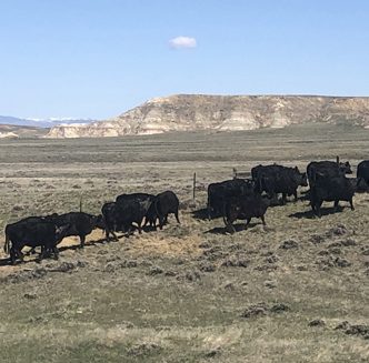
“We have equipment to help fight fires, but it takes time to fill the water truck. With fires like this, you don’t have time,” he continued. “We had a pasture with about 20 bulls and at one end of the pasture was the fire, so we took the feed truck out and they followed us to safe ground.”
Eisele noted King Ranch always plans on having periods of drought, so they have a grass bank available when they are faced with dry conditions.
“Along with losing our spring pasture ground, we lost a small haystack, but it could have been worse,” he said. “If it went the other direction, it would have burned our corrals, buildings and possibly our homes, so we are very lucky.”
The King Ranch has incorporated numerous land and resource conservation practices such as drought management and rotational grazing practices.
“You have to prepare the best you can and know drought will occur – not when will it occur – and know threats of wildfire are possible,” he concluded.
Preparing for wildfires
Wildfire season seems to start sooner, last longer and affect more individuals, families, animals and properties every year.
According to Oklahoma State University (OSU) Extension, wildfire preparedness is especially important when living on farms or ranches and having horses, cattle or other large animals creates unique challenges.
With just a small amount of preparation work and annual maintenance, properties can be made safer and better able to withstand wildfire, as wildfires can occur at any time of year.
OSU Extension reports preparation work should be done around homes and structures, such as trimming lawns, removing tall vegetation, pruning trees and shrubs and cleaning roofs and gutters of flammable debris, which can buy extra time in a wildfire event.
It is difficult to protect stored hay from blowing embers, and OSU suggests not storing all of an operation’s hay supply in one location. Instead, it should be placed it in several locations to reduce the risk of it all burning at once.
OSU also suggests having a livestock evacuation plan, which considers how and where livestock will be taken in the event of a wildfire, while also creating safe areas for livestock along fencelines or pasture corners with mineral placement.
Weather outlook
According to the National Interagency Fire Center’s (NIFC) National Significant Wildland Fire Potential Outlook report, released Feb. 1 for the outlook period of February through May 2024, El Niño continues in the equatorial Pacific Ocean, with the warmest sea surface temperature anomalies migrating from the eastern Pacific to the central Pacific Ocean during the past month.
“The Madden Julian Oscillation (MJO) has been unusually strong for an El Niño the past month, and El Niño has also been weakening during January, with current forecast guidance showing a rapid weakening of El Niño into spring,” NIFC reports.
The Climate Prediction Center forecasts El Niño will weaken into early spring, with a 73 percent chance of El Niño-Southern Oscillation (ENSO) neutral conditions for the timeframe of April through June.
“The MJO, Pacific Decadal Oscillation, Pacific-North American Pattern and Arctic Oscillation are likely to influence weather and climate during the outlook period, but El Niño will be the main driver,” NIFC states. “El Niño has peaked and will be weakening through spring, and by April, conditions may transition into the neutral phase, with ENSO neutral conditions likely by the late spring.”
NIFC’s outlook reports temperatures will continue to become normal as El Niño weakens. However, by the middle of spring, temperatures will start to trend above normal again and precipitation will be trending towards normal conditions as well, while going into May, conditions may start to trend back toward below normal.
Melissa Anderson is the editor of the Wyoming Livestock Roundup. Send comments on this article to roundup@wylr.net.


